Rice Road Bridge is one of San Antonio’s forgotten bridges that has been forgotten and sits unused in the Wheatley Heights neighborhood on the East Side. The bridge sits hidden away with overgrown vegetation in the Salado Creek Greenway and will remain so. This news article will explain the history behind the old Rice Road Bridge. Not the current Rice Road Bridge.

The origins of Rice Road Bridge dates back to 1898 when Emil Koehler & Emma C Koehler owned the land in what is currently Wheatley Heights. Possibly even earlier. F Street was the first name used for Rice Road before Rice Road was Rice Road. So Rice Road Bridge was F Street Bridge at first. (Ref: Bexar County Plats, Volume 2805, Page 36)


In the 1950s, Rice Road was more of a rural road with an open ditch that ran alongside the street. There was a bridge over Salado Creek called Rice Road Bridge. Mary Kopecki, a 50 year resident of the Eastern Triangle says, “Salado Creek flows through the Eastern Triangle area and the bridge on Rice Road was barely above the flowing creek.” (Ref: https://www.sanantonio.gov/Portals/0/Files/Planning/NPUD/Complete_FINAL_web_20090521.pdf)
The old Rice Road Bridge was prone to constant flooding as the bridge was located in a 100-year floodplain along with Salado Creek itself. Rice Road Bridge would be flooded more than 200 times a year sometimes. The streets were not paved.


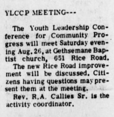
In 1968, Rev. R. A. Callies Sr. appeared before City Council to request traffic lights and sidewalks in the Wheatley Heights area and a new bridge over the Salado Creek at Rice Road. Mayor W. W. McAllister added a committee would be named to study needs throughout the city and a public hearing would be held. The population of the Wheatley Heights community and neighborhood was predominantly black at the time. (Ref: https://www.newspapers.com/newspage/65679402/)
“Rev. R. A. Callies Sr. appeared before the council to again request traffic lights and sidewalks in the Wheatley Heights area and a bridge over the Salado Creek at Rice Road. Councilman S. H. James told Rev. Callies the city is considering a bond issue this fall, and Mayor W. W. McAllister added a committee would be named to study needs throughout the city and a public hearing will be held.”
A petition soon began to circulate over construction of a bridge over Salado Crock at Rice Road and widening of sidewalks. (Ref: https://www.newspapers.com/newspage/60350283/)
"In a second petition, the committee cited the need for traffic lights, construction of a bridge over Salado Crock at Rice Road and widening of sidewalks."
Reverend R. A. Callies had the petition signed by 500 persons. He told City Council that sidewalks in the area are narrow and uneven and that school children must walk single file to go to school. He also noted the Salado Creek could cause a disaster when it floods in the area. He asked that a ramp that spanned the creek on Rice Road be replaced with a bridge. (Ref: https://www.newspapers.com/newspage/65674937/)
“Rev. Callies told the city council sidewalks in the area are narrow and uneven and that school children must walk single file to go to school. He also noted the Salado Creek could cause a disaster when it floods in the area. He asked that a ramp which now spans the creek on Rice Road be replaced with a bridge. He noted the ramp is used by children attending three schools nearby. He showed slides of many of the areas needing improvements.”

The old Rice Road had seen better days by 1976. Reverend R. A. Callies went to the City Council and asked for several improvements which included a bridge to be built over Salado Creek and Rice Road to make travel possible during high water uprisings. Reverend R. A. Callies and several residents of Wheatley Heights urged the City of San Antonio to build a new bridge for Rice Road in 1976, according to San Antonio Express. Funds were reallocated to construction of Rice Road Bridge, Ferris Avenue drainage programs and street repaving projects throughout the city. (Ref: https://www.newspapers.com/newspage/59548709/)
“The double use of federal money violates HUD rules and that project was dropped by the city along with the controversial golf course. The funds were reallocated to construction of Rice Road bridge, Ferris Avenue drainage programs and street repaving projects throughout the city. City Council made one major change in Guerra's proposal — adding $200,000 for four softball parks in the Kennedy High School area, proposed by Councilman Richard Teniente. Objection Funds were taken from the Rice Road bridge and St. Paul projects for the softball diamonds despite a strong protest from Councilman Claude Black. Black said he wanted funds for the Rice Road bridge project, to remain intact.”
However funds were taken from the Rice Road Bridge and St. Paul projects despite a strong protest from Councilman Claude Black. He wanted the funds for Rice Road Bridge project to remain in tact. (Ref: https://www.newspapers.com/image/59548709/?clipping_id=3873491)


Reverend R. A. Callies and several residents of Wheatley Heights urged the City of San Antonio to build a new bridge for Rice Road because the old bridge was becoming dilapidated and overflowing with water from Salado Creek as the old Rice Road Bridge was located in a 100-year floodplain. Rice Road Bridge would be flooded more than 200 times a year sometimes. Rice Road Bridge was also the site of major accidents due to sharp turns.
Reverend R. A. Callies pushed the City of San Antonio to mend roads initiating badly needed improvement and the extension of Martin Luther King Drive on Friday, November 17, 1978. (Ref: https://texashistory.unt.edu/ark:/67531/metapth399300/m1/8/?q=%22Rice+road+bridge%22)


According to the San Antonio Register, on October 11, 1979, the City of San Antonio agreed to close the old Rice Road until proper safety measure were taken. The old Rice Road Bridge was closed off to vehicular traffic on that day. (Ref: https://texashistory.unt.edu/ark:/67531/metapth1051768/m1/1/?q=%22Rice+road+bridge%22)


1979 marked a year of change for the old Rice Road Bridge. On Friday, May 25, 1979, a ribbon cutting ceremony took place at Rice Road and Brooksdale Drive with dedication ceremonies for the Larry Eugene Nance Memorial Bridge that was named after a boy named Larry Nance. A plaque was unveiled officially naming the new bridge in honor of the boy who died at the old Rice Road Bridge.

On July 7, 1964, a 10 year boy named Larry Nance lost his life a tragic drowning accident at the old Rice Road Bridge. Larry was playing and fishing with his younger brother, Bryant, on Salado Creek when he walked in to the water and accidentally drowned. Bryant said his brother walked into the creek fully clothed and "came up twice." He said he did not know Larry, one of seven Nance children went into the creek. The body was recovered about 10 feet from where the boy disappeared. (Ref: https://www.newspapers.com/newspage/58653177/)
[Bryant said his brother walked into the creek fully clothed and "came up twice." He said he did not know Larry, one of seven Nance children went into the creek. The body was recovered about 10 feet from where the boy disappeared. A distraught woman cries openly and neighbors, ail with concern in their eyes, comfort her at the search scene for the boy, who would have been a fifth grader at Whitcomb Riley Elementary School this fall.]


The new Rice Road Bridge opened in 1980. The new Rice Road Bridge would be 680 feet in length would actually go over Salado Creek by at least more than 10 feet. The new Rice Road Bridge would be a vehicular and pedestrian bridge unlike the old Rice Road Bridge. The new bridge was part of reconstruction of Rice Road between Hein Road and Brooksdale Drive. (Ref: https://texashistory.unt.edu/ark:/67531/metapth399759/m1/5/?q=%22Rice+road+bridge%22)


City of San Antonio gave a contract to Clearwater Constructors, Inc. to built the new Rice Road Bridge in 1980. Associated drainage workings included concrete channels under the bridge to carry runoff water into Salado Creek. The construction cost for the new Rice Road Bridge was $918,610. (Ref: https://texashistory.unt.edu/ark:/67531/metapth399759/m1/5/?q=%22Rice+road+bridge%22)
However problems were far from over. Reverend R. A. Callies complained to City Council that residents living in the floodplain below both bridges were being neglected. Residents were being flooded with water from Salado Creek whenever rain occurred.
By 1987, the area at Bunche Street and Rice Road in the Wheatley Heights neighborhood became a flooding ground and dumping ground. Wheatley Heights residents marched in front of City Hall to protests the need for permanent relief for residents living below the Rice Road bridge despite the fact that only 6 residents lived below the Rice Road Bridge on Bunche Street. During recent rains, residents could not get to their homes. Reverend R. A. Callies also added that residents were confronted all types of trash as Wheatley Heights became a dumping ground for trash. Bunche Street was a dumping ground for trash during the 1980s. (Ref: https://texashistory.unt.edu/ark:/67531/metapth842314/m1/1/?q=%22Nance+Bridge%22)


The original old Rice Road Bridge was still in tact and was still being used in 1981 by residents from Wheatley Heights who live on Rice Road, Bunche Street, and F Street. Primarily those who live on Rice Road and Bunche Street. The old Rice Road was torn down sometime prior to 1995. The exact date is unknown. The only remnants left are the modified curb where the old Rice Road used to connect.
The old Rice Road Bridge was located at 131 Rice Road, San Antonio, Texas, US 78220.