Arbor Trails Sinkhole is one of Austin’s lesser known sinkholes which not many people know about. This news article will explain the significance of Arbor Trails Sinkhole. 

Arbor Trails Sinkhole is quite significant due to having such uncommon geological characteristics for a sinkhole. Arbor Trails Sinkhole is a sudden cover-collapse sinkhole development which was developed during the karstic Cretaceous-age. This development of cover-collapse sinkholes was uncommon during the karstic Cretaceous-age. (Ref: BSEACD Report of Investigations 2013-0501, Page 1)
Arbor Trails Sinkhole is located very close to the estimated groundwater divide between the Cold Springs and Sunset Valley basins. The is because Arbor Trails Sinkhole developed proximal to a fault zone. (Ref: BSEACD Report of Investigations 2013-0501, Page 3)
The sinkhole known as Arbor Trails Sinkhole provided is located near a groundwater basin divide which are Cold Springs basins and Sunset Valley basins. Arbor Trails Sinkhole is located within the recharge zone of the Barton Springs segment of the Edwards Aquifer on a 72-acre property. (Ref: BSEACD Report of Investigations 2013-0501, Page 2)
A very shallow and large depression of 6 acres is centered in the middle. Several hardwood trees are present. However, the subdued nature of the feature and the subsequent disturbance from the highway that bisected the eastern portion of the depression made detection of the feature in the field difficult. (Ref: BSEACD Report of Investigations 2013-0501, Page 4)
Most of the geologic material in the sinkhole consisted of friable, highly altered (weathered) clayey limestone and terra rosa, an iron-rich clay soil. Very little competent bedrock was encountered in the excavations. There are dipping limestone beds along strike behind the northern retaining wall. (Ref: BSEACD Report of Investigations 2013-0501, Page 7)

A natural disaster occurred in January 2012 when Arbor Trails Sinkhole collapsed. On January 24, 2012, a 4.5 inch rainfall filled a Storm Water Retention Pond (SWRP), located in the recharge zone of the Barton Springs segment of the Edwards Aquifer, with about 10 feet of stormwater. Subsequently, a sinkhole developed within the floor of the SWRP, measuring about 30 feet in diameter and 12 feet deep. About 7 million gallons of stormwater drained into the aquifer through this opening. The sinkhole is located on a commercial development property called Arbor Trails, and hereafter is referred to as the Arbor Trails Sinkhole (ATS). A significant increase in turbidity at Barton Springs is associated with the late January rainfall. These types of increases are relatively common in this karst system. (Ref: BSEACD Report of Investigations 2013-0501, Page 1)


On January 25, 2012, maintenance crews noticed the pond was draining into a developing sinkhole. The size of the sinkhole was about 30 feet in diameter and 12 feet deep. About 7 million gallons of storm water drained into the aquifer through this opening. It is possible the drought and desiccation of the clay liner in the pond contributed to the compromise of the SWRP and development of the sinkhole. (Ref: BSEACD Report of Investigations 2013-0501, Page 6)
Prior to collapse of the Arbor Trails Sinkhole, central Texas had been experiencing a severe drought. Beginning in late January, rainfall and subsequent recharge brought the aquifer out of drought conditions (Ref: BSEACD Report of Investigations 2013-0501, Page 11)
Arbor Trails Sinkhole had been used as a dye tracing location for water quality testing purposes throughout the years. (Ref: https://digitalcommons.usf.edu/cgi/viewcontent.cgi?article=1065&context=kip_data)
A dye trace study was conducted by the Barton Springs/Edwards Aquifer Conservation District
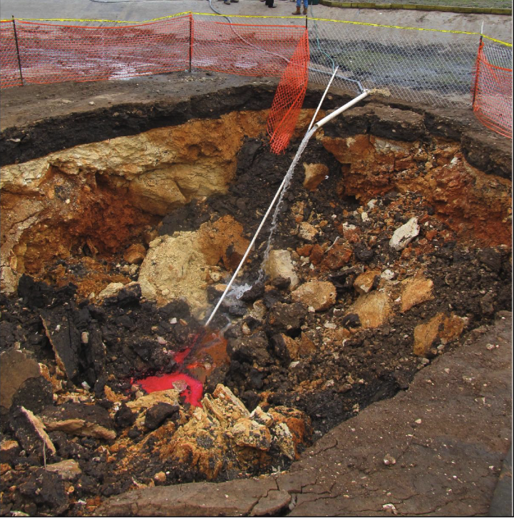
(District) and the City of Austin (CoA) on February 3, 2012 at about 1:00 PM. Phloxine B dye was injected into Arbor Trails Sinkhole on February 3, 2012 at about 1:00 PM with a mass of 16.27 lbs (7,382 g) that was mixed with water and then gravity injected via a hose using storm water from an adjacent pond. (Ref: BSEACD Report of Investigations 2013-0501, Page 10)
Edwards Aquifer Authority (EAA) analyzed 201 samples submitted by Barton Springs Edwards Aquifer Conservation District (BSEACD) from the Arbor Trails Sinkhole project. Although vials from autosamplers and grab samples required no preparation before analysis, dye must be extracted from charcoal receptors prior to analysis by eluting the charcoal (desorbing the dye) for one hour in a solution containing 95% of a 70% solution of 2-propanol in water and 5% sodium hydroxide. (Ref: BSEACD Report of Investigations 2013-0501, Appendix 1: Page 1)
The eluent was then decanted into a labeled glass vial and stored in darkness until analyzed. Uranine, Phloxine B, and Eosin in vials and eluents from charcoal were analyzed in the laboratory with a Perkin Elmer LS-50B Luminescence Spectrometer using synchronous scan and right-angle sampling geometry. The scan spanned 401 to 650 nm at 0.5-nm intervals, with a difference between excitation and emission wavelengths (delta lambda) of 15 nm and emission and excitation slits set at 6 nm. (Ref: BSEACD Report of Investigations 2013-0501, Appendix 1: Page 1)
A mass of about 7 kg (16 lbs) was mixed in a trash can and then gravity injected via a hose and polyvinyl chloride (PVC) pipe using water from an adjacent wet pond to Arbor Trails Sinkhole. (Ref: https://digitalcommons.usf.edu/cgi/viewcontent.cgi?article=1117&context=sinkhole_2013)
The dye solution was mixed with water from the adjacent storm water pond and gravity injected into the sinkhole with a hose and PVC pipe that was placed in the bottom of the sinkhole where the dye solution infiltrated. (Ref: BSEACD Report of Investigations 2013-0501, Page 9)


Mr. Greg Christopher, President of Christopher Commercial Inc. (CCI), is the owner of Arbor Trails Sinkhole. He is property owner of the Arbor Trails retail development. (Ref: https://digitalcommons.usf.edu/cgi/viewcontent.cgi?article=1117&context=sinkhole_2013)
Arbor Trails Sinkhole is located southwest of the intersection of West William Cannon Drive and MoPac (Loop 1) within the recharge zone of the Barton Springs segment of the Edwards Aquifer. Arbor Trails Sinkhole located near West William Cannon Drive and South MoPac Expressway, Austin, Texas, US 78749. (Ref: BSEACD Report of Investigations 2013-0501, Page 1)

No comments:
Post a Comment